[原]ArcGIS10.3集成一个新的Python开发包——SciPy
导语
本文只是概要翻译,有些信息并不是逐字逐句翻译,也有博主自己的大体描述,可能与翻译无关。感兴趣的读者可以直接参考英文描述。
正文
I recently caught up with Kevin Butler, a Product Engineer with the Geoprocessing and Analysis Team, to ask him a few questions about the integration between ArcGIS and SciPy.
地理学是一门科学,GIS技术可以帮助用户更好的理解这门科学,为了加强GIS和地理学的联系,Esri Ocean GIS Forum声明将集成ArcGIS与SciPy的集成,接下来是对Esri产品工程师 Kevin Butler的采访,Kevin主要负责GP和空间分析方面的。
什么是SciPy
- SciPy官网:http://www.scipy.org/
- SciPy是一个开源的Python算法库和数学工具包。
- SciPy包含的模块有最优化、线性代数、积分、插值、特殊函数、快速傅里叶变换、信号处理和图像处理、常微分方程求解和其他科学与工程中常用的计算。与其功能相类似的软件还有MATLAB、GNU Octave和Scilab。
- SciPy目前在BSD许可证下发布。它的开发由Enthought资助。
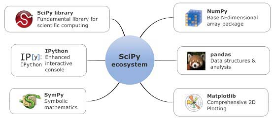
SciPy is not just one Python module but a collection of modules and is sometimes referred to as the SciPy Stack. The SciPy Stack consists of seven core packages:
![]() NumPy for numerical computation using arrays:NumPy 是使用数组进行数据计算,这个在现在ArcPy中数据访问DA也有该函数的介绍
NumPy for numerical computation using arrays:NumPy 是使用数组进行数据计算,这个在现在ArcPy中数据访问DA也有该函数的介绍
http://resources.arcgis.com/en/help/main/10.2/index.html#/TableToNumPyArray/018w00000018000000/
![]() SciPy, a collection of numerical algorithms :SciPy是一组数值算法库
SciPy, a collection of numerical algorithms :SciPy是一组数值算法库
![]() Matplotlib for 2D and 3D plotting:Matplotlib 是2D和3D绘图
Matplotlib for 2D and 3D plotting:Matplotlib 是2D和3D绘图
![]() Pandas for high-performance data structures:Pandas 是高性能的数据结构
Pandas for high-performance data structures:Pandas 是高性能的数据结构
![]() SymPy for symbolic mathematics and computer algebra:SymPy方向是符号数学和计算机代数
SymPy for symbolic mathematics and computer algebra:SymPy方向是符号数学和计算机代数
![]() IPython providing an interactive interface for quickly testing scripts and Nose which allows you to test your Python code.:IPython 提供交互式界面快速测试脚本,允许您测试您的 Python 代码
IPython providing an interactive interface for quickly testing scripts and Nose which allows you to test your Python code.:IPython 提供交互式界面快速测试脚本,允许您测试您的 Python 代码
ArcGIS平台最近的版本已经集成了NumPython和Matplotlib。经过升级后的 ArcGIS 10.2.1 目前包括 Python 2.7.5。第三方 Python 库也已经过升级:NumPy 已升级到 1.7.1,matplotlib 也已升级到 1.3.0。
更多介绍,详见积思园